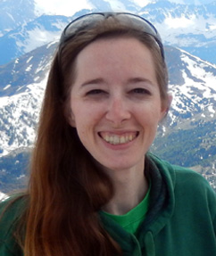
 Dr. Donna E. Selch is an Associate Professor in the Marine Science department at USCGA with specialties in Geographic Information Systems (GIS) and Remote Sensing, whose academic career bridges spatial science and environmental research. She holds advanced degrees in GIS and Remote Sensing, with expertise in spatial modeling, satellite image analysis, and environmental data visualization. Her teaching and research focus on applying geospatial technologies to understand complex ecological systems and support science-based conservation. Dr. Selch has flown both fixed wing and multi-rotor SR-UAS platforms for projects on micro-topography identification of archeological sites in active agriculture fields, on beaches for sea turtle nesting and shallow water mapping, and wetland ecosystem analysis using photogrammetric LiDAR.
While her professional foundation is rooted in geospatial science, Dr. Selch also harbors a deep passion for the study and conservation of sea turtles. Her work integrates satellite imagery, spatial tracking, and habitat modeling to better understand sea turtle migration, nesting behavior, and coastal habitat use. She is especially dedicated to educating students about sea turtle biology, conservation challenges, and the critical role individuals can play in protecting these remarkable marine species. Through this blend of technology and biology she brings a powerful interdisciplinary perspective to marine conservation, inspiring others to use spatial tools in service of protecting vulnerable ocean wildlife.
Dr. Donna E. Selch is an Associate Professor in the Marine Science department at USCGA with specialties in Geographic Information Systems (GIS) and Remote Sensing, whose academic career bridges spatial science and environmental research. She holds advanced degrees in GIS and Remote Sensing, with expertise in spatial modeling, satellite image analysis, and environmental data visualization. Her teaching and research focus on applying geospatial technologies to understand complex ecological systems and support science-based conservation. Dr. Selch has flown both fixed wing and multi-rotor SR-UAS platforms for projects on micro-topography identification of archeological sites in active agriculture fields, on beaches for sea turtle nesting and shallow water mapping, and wetland ecosystem analysis using photogrammetric LiDAR.
While her professional foundation is rooted in geospatial science, Dr. Selch also harbors a deep passion for the study and conservation of sea turtles. Her work integrates satellite imagery, spatial tracking, and habitat modeling to better understand sea turtle migration, nesting behavior, and coastal habitat use. She is especially dedicated to educating students about sea turtle biology, conservation challenges, and the critical role individuals can play in protecting these remarkable marine species. Through this blend of technology and biology she brings a powerful interdisciplinary perspective to marine conservation, inspiring others to use spatial tools in service of protecting vulnerable ocean wildlife.
Education
- Ph.D., Geosciences, Florida Atlantic University, 2016
- M.A., Geography Geographical Information Systems & Remote Sensing), 2012
- B.S., Biology (Marine Biology), 2006
Courses Taught
- Geospatial Sciences 1
- Geospatial Sciences 2
- Sea Turtles
- Fundamentals of UxS Operations
- Maritime Remote Sensing
- Capstone Research Experience 1,2,3
- Research in Marine Science, Research in Geospatial Science, Projects in Marine Sciences
Selected Publications and Presentations
- Selch, D., and M. Rochelo. Parsing Whale Data: An Instructional Guide. Society for Conservation of GIS (SCGIS) Annual International Conference. Virtual, July 6-8, 2022.
- Selch, D., C. J. Abbott, and C. Zhang. 2020. Applying Point Spectroscopy Data to Assess the Effects of Salinity and Sea Level Rise on Canopy Water Content of Juncus roemerianus. Multi-Sensor System Applications in the Everglades Ecosystem. CRC Press.
- Smith, M. E., D. Selch, and C. Zhang. 2020. Applying Point Spectroscopy Data to Characterize Sand Properties. Multi-Sensor System Applications in the Everglades Ecosystem. CRC Press.
- Selch, Donna, Ben Keslowitz, and Jamie Lavin. 2020. “Sustainable Sites at Stony Brook University.” Sustainability Adventure Lab. (Mobile geocaching educational experience) https://adventure.geocaching.com/campus
- Selch, D. and M. J. Rochelo. 2019. Uncovering the Past using Remote Sensing and GIS. ESRI User Conference, San Diego, CA.
- Selch, D., M. J. Rochelo, and C. Zhang. 2019. Establishing Methodology for Hindcasting Sea Surface Salinity using Landsat Imagery. Association of American Geographers Annual Conference (AAG), Washington, D.C.
- Selch, D., M. J. Rochelo, and C. Davenport. 2018. UAV Remote Sensing Exploration of Newly Discovered Paleo Sites in South Florida. Association of American Geographers Annual Conference (AAG), New Orleans, LA.
- Rider, T. and D. Selch. Archipelagos & Aquapelagos. 2018. The Ebb and Flow of Flax Pond. The Pratt Institute, Brooklyn, NY.
- Selch, D. 2017. Long Island GIS User Conference. Drone Research in Coastal Communities. Stony Brook, NY
- Selch, D., and M. J. Rochelo. 2017. UAV High Resolution Data and Photogrammetry Allows for Valuable Investigation and Analysis of Wetland Communities. Association of American Geographers Annual Conference (AAG).
- Selch, D., M. Rochelo, and C. Davenport. 2016. Exploring the use of LiDAR Remote Sensing Data to Illuminate Belle Glade Earthworks. Society for American Archaeology. SAA 81st Annual Meeting Orlando.
- Zhang, C., D. Selch, and H. Cooper. 2016. A Framework to Combine Three Remotely Sensed Data for Vegetation Mapping in the Central Florida Everglades. Wetlands, 36, 201-213.
- Rochelo, M. J., C. Davenport, and D. Selch. 2015. Revealing Pre-Historic Native American Belle Glade Earthworks in the Northern Everglades utilizing Airborne LiDAR. Journal of Archeological Science: Reports, 2: 624-643.
- Cooper, H. M., C. Zhang, D. Selch. 2015. Incorporating uncertainty of groundwater modeling in sea-level rise assessment: A case study in South Florida. Climate Change. doi: 10.1007/s10584-015-1334-1
- Selch, D., J. Reed, and B. Cousin. 2005. Oculina Reefs in Jeopardy: Deep Sea Trawling (documentary). Harbor Branch Oceanographic Institution.
Honors and Awards
- Smith, M.E., D. Selch, A. Oleinik, and C. Zhang. Sand Analysis Using a Combined Spectroscopic and Microscopic Technique. Association of American Geographers Annual Conference (AAG), Boston, MA. April 5-9, 2017. 2nd place Student Illustrated Paper.
- ESRI UC Map Gallery 2016: Selch, D., M. Rochelo, and C. Zhang. June 27- July 1, 2016. ESRI User Conference 2016 Map Gallery, San Diego, CA. Correcting Imagery for Accurate Surface Water Salinity Models using GIS and Remote Sensing. 1st Place Best Analytic Presentation
- ESRI UC Map Gallery 2016: Selch, D., M. Rochelo, F. Dalgleish, L. Cherubin. June 27- July 1, 2016. Utilizing Drones: Data Acquisition to Finished Products. ESRI User Conference 2016 Map Gallery, San Diego, CA. 3rd Place for Best Instructional Presentation
- Selch, D., and C. Zhang, 2016. Extracting Benthic Habitat from Shallow Water Hyperspectral Imagery Examining Reflectance Influences. AAG. 1st Place Norbert P. Psuty Student Paper Merit Award
- Selch, D., C. Zhang, and A. Oleinik, 2014. Building a Spectral Library for Sand Classification Using an ASD Spectrometer. AAG. 1st Place Illustrated Paper
Professional Affiliations
- Academy of Model Aeronautics
- American Society for Photogrammetry and Remote Sensing
- Association of American Geographers
Certifications of Professional Registrations
- ESRI ArcGIS Pro Foundation 2101 – 2022
- Remote Pilot License (Part 107) Federal Aviation Administration 2017
- Graduate Remote Sensing Certificate 2015
- Advanced GIS Certificate 2013
- GIS Certificate 2006